

America’s Next Indoor Snow Centre Takes Shape
Construction of a new indoor snow centre for skiers, boarders and tubers appears to be making good progress at Heritage Farm in Wayne County, West Virginia.

Next 3 days weather summary:chuva mod. (total 13.0mm), mais intensa na Terça à noite. quente (máx. 22°C na Terça de manhã, mín 9°C na Quarta à noite). Ventos diminuem (ventos frescos de Sul na Terça à tarde, vento fraco de Oeste-Sudoeste na Quinta à noite). | Dias 4-6 Mont Orford Resumo do Tempoprincipalmente seco. quente (máx. 24°C no Sábado à tarde, mín 15°C na Sexta de noite). o vento será geralmente fraco. | |||||||||||||||||
Terça 21 | Quarta 22 | Quinta 23 | Sexta 24 | Sábado 25 | Domingo 26 | |||||||||||||
manhã | tarde | noite | manhã | tarde | noite | manhã | tarde | noite | manhã | tarde | noite | manhã | tarde | noite | manhã | tarde | noite | |
parcial/ nublado | chuva fraca | aguaceiros | aguaceiros | chuva fraca | parcial/ nublado | parcial/ nublado | céu limpo | céu limpo | céu limpo | parcial/ nublado | parcial/ nublado | céu limpo | parcial/ nublado | parcial/ nublado | parcial/ nublado | parcial/ nublado | céu limpo | |
km/h | ||||||||||||||||||
Mapa de neve |  |  |  |  |  |  | ||||||||||||
— | — | — | — | — | — | — | — | — | — | — | — | — | — | — | — | — | — | |
mm | — | 2 | 8 | 2 | 1 | — | — | — | — | — | — | — | — | — | — | — | — | — |
max °C | 22 | 21 | 18 | 17 | 14 | 12 | 13 | 17 | 15 | 20 | 21 | 18 | 21 | 24 | 20 | 21 | 23 | 20 |
min °C | 18 | 19 | 16 | 15 | 14 | 9 | 10 | 17 | 12 | 16 | 21 | 15 | 17 | 23 | 16 | 18 | 22 | 17 |
chill °C | 18 | 18 | 15 | 13 | 12 | 5 | 6 | 16 | 11 | 16 | 21 | 15 | 17 | 23 | 16 | 18 | 22 | 17 |
Humid. % | 58 | 80 | 88 | 93 | 76 | 84 | 61 | 52 | 71 | 48 | 48 | 73 | 47 | 50 | 80 | 52 | 59 | 79 |
Nível de congel. m | 3950 | 3950 | 3900 | 3600 | 3400 | 3350 | 2350 | 3050 | 2850 | 3150 | 3450 | 3100 | 3650 | 3500 | 3400 | 3550 | 3700 | 3700 |
5:20 | — | — | 5:20 | — | — | 5:22 | — | — | 5:22 | — | — | 5:24 | — | — | 5:26 | — | — | |
— | — | 8:29 | — | — | 8:28 | — | — | 8:27 | — | — | 8:25 | — | — | 8:24 | — | — | 8:23 | |
Vire pro e carve em:
Informações de avalanche: Avalanche Canada
Últimos relatórios de neve perto de Mont Orford:
| Profundidade da neve no topo | 0 cm |
|---|---|
| Profundidade da neve mais baixa | 0 cm |
| Profundidade da queda de neve fresca | — |
| Quando foi a última vez que nevou? | 2 May 2026 |
0.0 | Dias de sol com neve pó Neve fresca, principalmente ensolarado, vento fraco. |
|---|---|
0.0 | Dias de neve pó Neve fresca, sol limitado, qualquer vento. |
0.0 | dias de sol Neve média, na maioria das vezes ensolarado, vento fraco. |

As tabelas acima dão a previsão do tempo para Mont Orford à altitude específica de 583 m. Nossos sofisticados modelos de tempo permitem-nos obter a previsão de neve para estações no topo, na parte média e na baixa de Mont Orford. Para acessar a previsão do tempo para outras elevações, utilize o botão tab acima da tabela. Para uma visão mais ampla do tempo, dê uma olhada em Weather Map" of Canada.
Click here para ler mais informações sobre os níveis de congelamento e de como nós prevemos nossas temperaturas.
Geral 4.0 baseado em 3 Votos e 1 avaliação
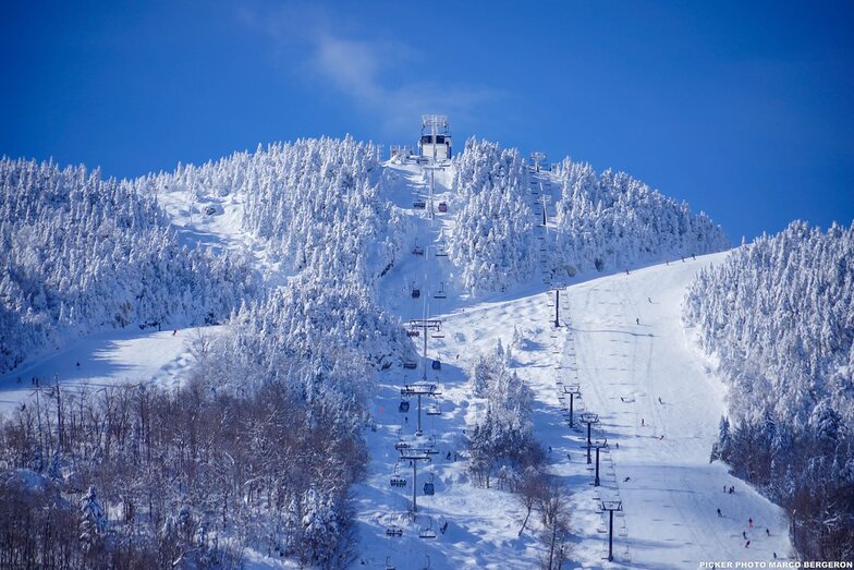
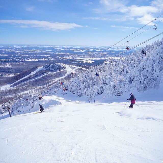
Skied Mont Orford for the first time Dec 30/19 to Jan 2/19. Family of 5: 2 adults, 2 youth(13 & 16), 1 child(10yo), all of whom have been skiing for about 7 years (Bristol Mtn, Gore, Mt Ste. Anne, Massif, Tremblant). Very icy the first day but got a great dump of snow for the next three days. Stuck to the greens and blues as the blacks were very icy due to wind. The 4km and Famiiliale were quite good as well as Magog. The kids loved Escapade and Foret Magique. There is only one real building but it is large and we had no problems finding space for our stuff. There is a microwave in the basement along with nice washrooms. There were really only two lifts: express quad and an express hybrid (6 seat lift/8 seat gondola). There was a triple working every once in a while part way up the main hill. The lift lines can get long, especially for the quad - lots of switchbacks. The staff was exceptionally nice and put up with my terrible French and switched to English with no problems. It is nice buying lift tickets inside rather than waiting in the cold. There was only a long line on our last day but it moved very quickly. The views from the summits are gorgeous. You can see across the valley and the lake to Owl's Head, another resort. The town of Magog is larger than you think and has everything you need (multiple grocery stores, CTC, Walmart). There is also a 2.5km ice skating trail down by the lake that is free (parking costs a little bit).
Andrea de Canada escreve:
Skied Mont Orford for the first time Dec 30/19 to Jan 2/19. Family of 5: 2 adults, 2 youth(13 & 16), 1 child(10yo), all of whom have been skiing for about 7 years (Bristol Mtn, Gore, Mt Ste. Anne, Massif, Tremblant). Very icy the first day but got a great dump of snow for the next three days. Stuck to the greens and blues as the blacks were very icy due to wind. The 4km and Famiiliale were quite good as well as Magog. The kids loved Escapade and Foret Magique. There is only one real building but it is large and we had no problems finding space for our stuff. There is a microwave in the basement along with nice washrooms. There were really only two lifts: express quad and an express hybrid (6 seat lift/8 seat gondola). There was a triple working every once in a while part way up the main hill. The lift lines can get long, especially for the quad - lots of switchbacks. The staff was exceptionally nice and put up with my terrible French and switched to English with no problems. It is nice buying lift tickets inside rather than waiting in the cold. There was only a long line on our last day but it moved very quickly. The views from the summits are gorgeous. You can see across the valley and the lake to Owl's Head, another resort. The town of Magog is larger than you think and has everything you need (multiple grocery stores, CTC, Walmart). There is also a 2.5km ice skating trail down by the lake that is free (parking costs a little bit).
Clique aqui para submeter a sua própria avaliação de Mont Orford

 Nearest