

America’s Next Indoor Snow Centre Takes Shape
Construction of a new indoor snow centre for skiers, boarders and tubers appears to be making good progress at Heritage Farm in Wayne County, West Virginia.

Next 3 days weather summary:chuva mod. (total 16.0mm), mais intensa na Qui de manhã. Muito ameno (máx. 16°C na Quarta à tarde, mín 9°C na Quarta de manhã). o vento será geralmente fraco. | Dias 4-6 Waidring Resumo do TempoChuva intensa (total 28.0mm), mais intensa durante Segunda de manhã. quente (máx. 21°C no Sábado à tarde, mín 11°C no Domingo à noite). o vento será geralmente fraco. | ||||||||||||||||
Ter 21 | Quarta 22 | Quinta 23 | Sexta 24 | Sábado 25 | Domingo 26 | ||||||||||||
tarde | noite | manhã | tarde | noite | manhã | tarde | noite | manhã | tarde | noite | manhã | tarde | noite | manhã | tarde | noite | |
aguaceiros | aguaceiros | céu limpo | céu limpo | aguaceiros | aguaceiros | Risco Trovoada | aguaceiros | céu limpo | céu limpo | céu limpo | parcial/ nublado | céu limpo | aguaceiros | Risco Trovoada | chuva fraca | chuva fraca | |
km/h | |||||||||||||||||
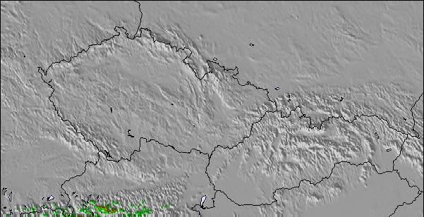
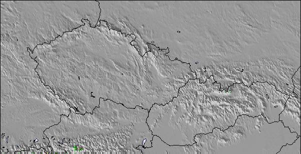
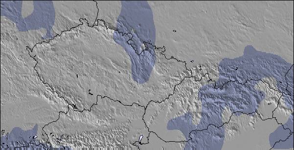
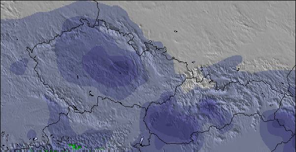
Mapa de neve |  |  |  |  |  |  | |||||||||||
— | — | — | — | — | — | — | — | — | — | — | — | — | — | — | — | — | |
mm | 1 | 2 | — | — | 2 | 3 | 4 | 4 | — | — | — | — | — | 6 | 3 | 5 | 5 |
max °C | 14 | 12 | 12 | 16 | 15 | 10 | 11 | 11 | 12 | 16 | 14 | 17 | 21 | 20 | 14 | 13 | 14 |
min °C | 13 | 10 | 9 | 14 | 10 | 9 | 11 | 10 | 10 | 14 | 13 | 15 | 20 | 15 | 14 | 12 | 11 |
chill °C | 12 | 9 | 8 | 13 | 9 | 8 | 10 | 10 | 10 | 14 | 13 | 15 | 20 | 15 | 14 | 10 | 10 |
Humid. % | 66 | 71 | 57 | 41 | 61 | 86 | 73 | 65 | 52 | 37 | 48 | 37 | 37 | 63 | 79 | 86 | 66 |
Nível de congel. m | 2900 | 2700 | 2900 | 3050 | 3050 | 2800 | 2800 | 2650 | 3000 | 3450 | 3850 | 3900 | 4200 | 4100 | 3550 | 3350 | 3150 |
— | — | 5:33 | — | — | 5:35 | — | — | 5:35 | — | — | 5:37 | — | — | 5:37 | — | — | |
— | 8:58 | — | — | 8:57 | — | — | 8:55 | — | — | 8:54 | — | — | 8:53 | — | — | 8:52 | |
Vire pro e carve em:
Informações de avalanche: European Avalanche Warning Services (EAWS)
Últimos relatórios de neve perto de Waidring:
| Profundidade da neve no topo | — |
|---|---|
| Profundidade da neve mais baixa | — |
| Profundidade da queda de neve fresca | — |
| Quando foi a última vez que nevou? | 16 May 2026 |
0.0 | Dias de sol com neve pó Neve fresca, principalmente ensolarado, vento fraco. |
|---|---|
0.0 | Dias de neve pó Neve fresca, sol limitado, qualquer vento. |
0.0 | dias de sol Neve média, na maioria das vezes ensolarado, vento fraco. |
As tabelas acima dão a previsão do tempo para Waidring à altitude específica de 1340 m. Nossos sofisticados modelos de tempo permitem-nos obter a previsão de neve para estações no topo, na parte média e na baixa de Waidring. Para acessar a previsão do tempo para outras elevações, utilize o botão tab acima da tabela. Para uma visão mais ampla do tempo, dê uma olhada em Weather Map" of Austria.
Click here para ler mais informações sobre os níveis de congelamento e de como nós prevemos nossas temperaturas.
Geral 3.9 baseado em 5 Votos e 3 avaliações
Skied here several times, during Feb/March, as the snow was so much better than most other resorts, in the region, this year but it was often very busy because of this. Steinplatte is a great area for blue run skiers and there are some runs where even the most timid of skiers can allow their skis to stay in the foreline. The slopes are very wide and the lifts are very modern. As a consequence, when it is busy you really have to watch your back as there can be a large number of technically poor skiers hammering down the hill and it is sometimes quite dangerous to finish your turns because of the risk of someone skiing into you from behind. On quieter days, weekdays in January and just before Easter it is an intermediates paradise. If it gets too busy or the visibility is poor you can ski down to Winklmoos, in Germany, and usually avoid the queues and ski on tree-lined runs. This has the best terrain I have ever seen for beginners and very timid skiers afraid of any gradient, and holds the snow very well. Pros: incredible terrain for timid skiers, usually the best snow conditions in the area, fast efficient lift system, easy to get to by car. Cons: often very busy, a lot of idiot skiers, during the holidays, skiing too fast for their ability, not enough mountain restaurants which can get over-crowded, prone to misty whiteout conditions (most of the skiing is above the tree line). Top tip: always ski here on a sunny weekday in low season.
Mark Gunston de United Kingdom escreve:
Skied here several times, during Feb/March, as the snow was so much better than most other resorts, in the region, this year but it was often very busy because of this. Steinplatte is a great area for blue run skiers and there are some runs where even the most timid of skiers can allow their skis to stay in the foreline. The slopes are very wide and the lifts are very modern. As a consequence, when it is busy you really have to watch your back as there can be a large number of technically poor skiers hammering down the hill and it is sometimes quite dangerous to finish your turns because of the risk of someone skiing into you from behind. On quieter days, weekdays in January and just before Easter it is an intermediates paradise. If it gets too busy or the visibility is poor you can ski down to Winklmoos, in Germany, and usually avoid the queues and ski on tree-lined runs. This has the best terrain I have ever seen for beginners and very timid skiers afraid of any gradient, and holds the snow very well.
Pros: incredible terrain for timid skiers, usually the best snow conditions in the area, fast efficient lift system, easy to get to by car.
Cons: often very busy, a lot of idiot skiers, during the holidays, skiing too fast for their ability, not enough mountain restaurants which can get over-crowded, prone to misty whiteout conditions (most of the skiing is above the tree line).
Top tip: always ski here on a sunny weekday in low season.

 Nearest