

America’s Next Indoor Snow Centre Takes Shape
Construction of a new indoor snow centre for skiers, boarders and tubers appears to be making good progress at Heritage Farm in Wayne County, West Virginia.

Next 3 days weather summary:Chuva fraca (total 6.0mm), caindo principalmente no Domingo à tarde. Muito ameno (máx. 13°C na Segunda à tarde, mín 4°C na Terça à noite). o vento será geralmente fraco. | Dias 4-6 Riederalp - Aletsch Resumo do TempoAlguns chuviscos, mais intensos durante Quinta à tarde. Muito ameno (máx. 13°C na Quarta à tarde, mín 3°C na Qui à noite). o vento será geralmente fraco. | ||||||||||||||||
Dom 19 | Segunda 20 | Terça 21 | Quarta 22 | Quinta 23 | Sexta 24 | ||||||||||||
tarde | noite | manhã | tarde | noite | manhã | tarde | noite | manhã | tarde | noite | manhã | tarde | noite | manhã | tarde | noite | |
aguaceiros | céu limpo | céu limpo | aguaceiros | aguaceiros | Risco Trovoada | aguaceiros | céu limpo | céu limpo | céu limpo | parcial/ nublado | nublado | aguaceiros | céu limpo | céu limpo | parcial/ nublado | parcial/ nublado | |
km/h | |||||||||||||||||
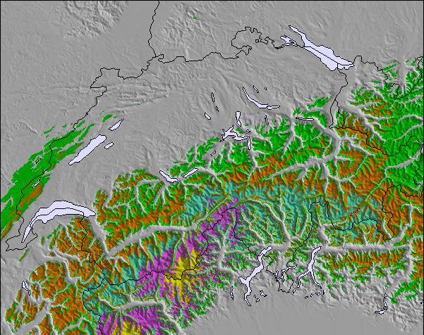
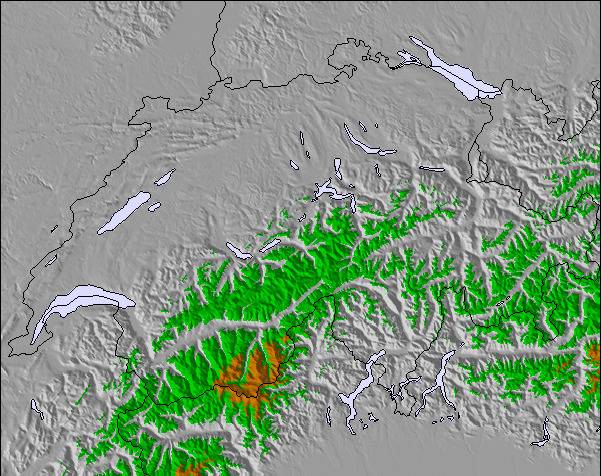
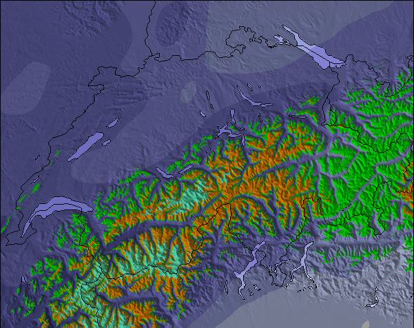
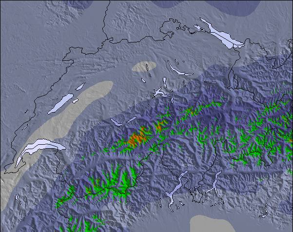
Mapa de neve |  |  |  |  |  |  | |||||||||||
— | — | — | — | — | — | — | — | — | — | — | — | — | — | — | — | — | |
mm | 1 | — | — | 2 | 1 | 1 | 1 | — | — | — | — | — | 1 | — | — | — | — |
max °C | 12 | 10 | 11 | 13 | 11 | 11 | 12 | 9 | 11 | 13 | 10 | 9 | 10 | 8 | 11 | 13 | 9 |
min °C | 12 | 5 | 8 | 13 | 5 | 8 | 12 | 4 | 8 | 13 | 4 | 7 | 10 | 3 | 7 | 13 | 5 |
chill °C | 11 | 3 | 7 | 12 | 3 | 6 | 11 | 3 | 8 | 12 | 2 | 5 | 8 | 1 | 6 | 12 | 4 |
Humid. % | 58 | 72 | 67 | 55 | 56 | 57 | 57 | 46 | 43 | 50 | 56 | 59 | 52 | 44 | 25 | 45 | 49 |
Nível de congel. m | 3850 | 3750 | 3650 | 3950 | 3900 | 3650 | 3750 | 3800 | 3700 | 3950 | 3700 | 3300 | 3500 | 3800 | 3850 | 4000 | 3850 |
— | — | 5:54 | — | — | 5:54 | — | — | 5:56 | — | — | 5:58 | — | — | 5:58 | — | — | |
— | 9:13 | — | — | 9:13 | — | — | 9:12 | — | — | 9:10 | — | — | 9:09 | — | — | 9:08 | |
Vire pro e carve em:
Informações de avalanche: European Avalanche Warning Services (EAWS)
Últimos relatórios de neve perto de Riederalp - Aletsch:
| Profundidade da neve no topo | — |
|---|---|
| Profundidade da neve mais baixa | — |
| Profundidade da queda de neve fresca | — |
| Quando foi a última vez que nevou? | 10 Jun 2026 |
0.0 | Dias de sol com neve pó Neve fresca, principalmente ensolarado, vento fraco. |
|---|---|
0.0 | Dias de neve pó Neve fresca, sol limitado, qualquer vento. |
0.0 | dias de sol Neve média, na maioria das vezes ensolarado, vento fraco. |
As tabelas acima dão a previsão do tempo para Riederalp - Aletsch à altitude específica de 2264 m. Nossos sofisticados modelos de tempo permitem-nos obter a previsão de neve para estações no topo, na parte média e na baixa de Riederalp - Aletsch. Para acessar a previsão do tempo para outras elevações, utilize o botão tab acima da tabela. Para uma visão mais ampla do tempo, dê uma olhada em Weather Map" of Switzerland.
Click here para ler mais informações sobre os níveis de congelamento e de como nós prevemos nossas temperaturas.
Geral 4.1 baseado em 1 Voto e 1 avaliação
Almost every Christmas I spend the holiday in Fiesch in the Aletsch region with my family. Fiesch, Fiescheralp, Betmmeralp and Riederalp have many not too expensive chalets for rent, ideal for families. The villages are charming and snow covered, breathing Swiss tradition. Don’t expect a thrilling night life. The Alps and the great Aletsch gletscher are UNESCO protected, securing a beautiful environment for the future. The panoramas are one of the most beautiful in European Alps. Since the UNESCO status, no new lifts have been opened, but the capacity and quality of the existing lifts has been increased during the last years. A good connection lift between Bettmeralp and Kuhboden (Fiescheralp) is lacking and the slopes are for good skiers only. When the red Aletsch piste in Bettmeralp is closed, you have to take a few small lifts to get in Riederalp. Also within Riederalp slopes are not good connected. Especially for snowboarders this can be annoying. The ski area has some exciting runs. You can ski from the Eggishorn (2900 metres) to Fiesch (1050 metre), a drop of almost 2 km with steep slopes and a controlled off-piste route. The real pros can take a steep freeride route from the top with their own security equipment. Another experience is the steep, but short, slope after skiing through a 100 meter skitunnel from the Bettmerhorn. You can choose to ski off-piste to Bettmeralp. In Riederalp sometimes a slalom run is opened, the one in Fiescheralp is for groups only. After a good dump of snow, the young locals know, you can descend from Bettmeralp and Riederalp into the valley. These are freeride routes and not on the map. With the Aletsch ski pass you can visit Muhlebach near Ernen. This calm and tiny area only has four lifts, but with nice red runs and off piste possibilities when the off piste snow in the Aletsch area already has been packed by an overkill of skiers and boarders (in the holidays). It seems the Swiss are trying to avoid risk (more than the French do). This area is missing a proper fun park with a lift. In Fiescheralp, there are some cheap and badly groomed plastic slides with scratches on the surface, a cheap rainbow and some badly shaped jumps. In Bettmeralp there are three jumps of a quality far below international freestyle standards. The slope control doesn’t like people building their own kicker. Sometimes I ended up confused when lifts are closed due to “bad weather”, despite perfect snow conditions. The Aletsch area is not for freestyle. Great for families. Also expert skiers can have fun!
Koen Braak de The Netherlands escreve:
Almost every Christmas I spend the holiday in Fiesch in the Aletsch region with my family. Fiesch, Fiescheralp, Betmmeralp and Riederalp have many not too expensive chalets for rent, ideal for families. The villages are charming and snow covered, breathing Swiss tradition. Don’t expect a thrilling night life.
The Alps and the great Aletsch gletscher are UNESCO protected, securing a beautiful environment for the future. The panoramas are one of the most beautiful in European Alps. Since the UNESCO status, no new lifts have been opened, but the capacity and quality of the existing lifts has been increased during the last years. A good connection lift between Bettmeralp and Kuhboden (Fiescheralp) is lacking and the slopes are for good skiers only. When the red Aletsch piste in Bettmeralp is closed, you have to take a few small lifts to get in Riederalp. Also within Riederalp slopes are not good connected. Especially for snowboarders this can be annoying.
The ski area has some exciting runs. You can ski from the Eggishorn (2900 metres) to Fiesch (1050 metre), a drop of almost 2 km with steep slopes and a controlled off-piste route. The real pros can take a steep freeride route from the top with their own security equipment. Another experience is the steep, but short, slope after skiing through a 100 meter skitunnel from the Bettmerhorn. You can choose to ski off-piste to Bettmeralp.
In Riederalp sometimes a slalom run is opened, the one in Fiescheralp is for groups only.
After a good dump of snow, the young locals know, you can descend from Bettmeralp and Riederalp into the valley. These are freeride routes and not on the map.
With the Aletsch ski pass you can visit Muhlebach near Ernen. This calm and tiny area only has four lifts, but with nice red runs and off piste possibilities when the off piste snow in the Aletsch area already has been packed by an overkill of skiers and boarders (in the holidays).
It seems the Swiss are trying to avoid risk (more than the French do). This area is missing a proper fun park with a lift. In Fiescheralp, there are some cheap and badly groomed plastic slides with scratches on the surface, a cheap rainbow and some badly shaped jumps. In Bettmeralp there are three jumps of a quality far below international freestyle standards. The slope control doesn’t like people building their own kicker. Sometimes I ended up confused when lifts are closed due to “bad weather”, despite perfect snow conditions.
The Aletsch area is not for freestyle. Great for families. Also expert skiers can have fun!
Clique aqui para submeter a sua própria avaliação de Riederalp - Aletsch

 Nearest