


America’s Next Indoor Snow Centre Takes Shape
Construction of a new indoor snow centre for skiers, boarders and tubers appears to be making good progress at Heritage Farm in Wayne County, West Virginia.

Next 4 days weather summary:Chuva fraca (total 3.0mm) primeiro, depois vai ficando mais frio com ligeira queda de neve na Terça à tarde. Condições de congelação e descongelação (máx. 4°C na Seg à noite, mín -2°C na Terça à noite). o vento será geralmente fraco. | Dias 5-7 Kaunertal Resumo do TempoSuave com chuva moderada (total 10.0mm) no Sábado à noite, ficando mais frio com uma leve camada de neve, caida principalmente no Domingo à tarde. Condições de congelação e descongelação (máx. 9°C no Sábado à tarde, mín -2°C na Qui à noite). o vento será geralmente fraco. | |||||||||||||||
Terça 21 | Quarta 22 | Quinta 23 | Sexta 24 | Sábado 25 | ||||||||||||
noite | manhã | tarde | noite | manhã | tarde | noite | manhã | tarde | noite | manhã | tarde | noite | manhã | tarde | noite | |
céu limpo | Risco Trovoada | Neve fraca | Neve fraca | céu limpo | céu limpo | parcial/ nublado | neve fraca | Neve fraca | Neve fraca | céu limpo | céu limpo | parcial/ nublado | céu limpo | parcial/ nublado | chuva mod. | |
km/h | ||||||||||||||||
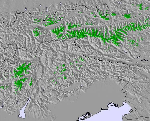
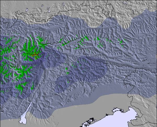
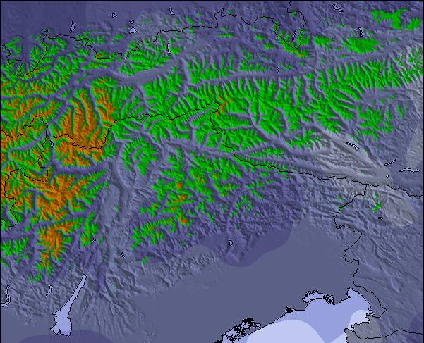
Mapa de neve |  |  |  |  |  |  | ||||||||||
— | — | 2 | — | — | — | — | — | 1 | — | — | — | — | — | — | — | |
mm | — | 3 | — | — | — | — | — | — | — | — | — | — | — | — | — | 10 |
max °C | 4 | 3 | 2 | 1 | 0 | 4 | 2 | 0 | 1 | -1 | 1 | 4 | 5 | 5 | 9 | 5 |
min °C | 3 | 2 | 2 | -2 | 0 | 2 | 0 | -1 | 0 | -2 | 1 | 3 | 4 | 5 | 8 | 3 |
chill °C | 1 | -1 | -1 | -5 | -3 | 0 | -4 | -4 | -4 | -6 | -2 | 1 | 4 | 3 | 7 | 1 |
Humid. % | 70 | 67 | 64 | 82 | 46 | 53 | 72 | 84 | 62 | 74 | 28 | 40 | 31 | 50 | 38 | 87 |
Nível de congel. m | 3700 | 3500 | 3450 | 2900 | 3200 | 3750 | 3250 | 3100 | 3300 | 2750 | 3400 | 3950 | 3950 | 3900 | 4300 | 3700 |
— | 5:41 | — | — | 5:43 | — | — | 5:43 | — | — | 5:45 | — | — | 5:47 | — | — | |
— | — | — | 9:02 | — | — | 9:01 | — | — | 9:00 | — | — | 9:00 | — | — | 8:59 | |
Vire pro e carve em:
Informações de avalanche: European Avalanche Warning Services (EAWS)
Últimos relatórios de neve perto de Kaunertal:
| Profundidade da neve no topo | 0 cm |
|---|---|
| Profundidade da neve mais baixa | 0 cm |
| Profundidade da queda de neve fresca | — |
| Quando foi a última vez que nevou? | 12 Jun 2026 |
0.0 | Dias de sol com neve pó Neve fresca, principalmente ensolarado, vento fraco. |
|---|---|
0.6 | Dias de neve pó Neve fresca, sol limitado, qualquer vento. |
0.0 | dias de sol Neve média, na maioria das vezes ensolarado, vento fraco. |
As tabelas acima dão a previsão do tempo para Kaunertal à altitude específica de 3160 m. Nossos sofisticados modelos de tempo permitem-nos obter a previsão de neve para estações no topo, na parte média e na baixa de Kaunertal. Para acessar a previsão do tempo para outras elevações, utilize o botão tab acima da tabela. Para uma visão mais ampla do tempo, dê uma olhada em Weather Map" of Austria.
Click here para ler mais informações sobre os níveis de congelamento e de como nós prevemos nossas temperaturas.
Geral 3.9 baseado em 17 Votos e 2 avaliações
The first big advantage of the Kaunertal is the ability to drive with your car up to 2750m, directly to the glacier. The drive from Feichten (last town) to the glacier is about 30km, beautiful landscapes and a huge lake included. The ski resorts offers everything for a beginner and an expert. A great funpark for snowboarder (beginner and experts), a halfpipe and obstacles. There are six surface lifts and two chair lifts (down to 2150m). So you are able to carve down from 3162m to 2150m on one piece, great! The next big thing is, that there are no masses of tourists and the tracks are shaped nearly daily. My favorite resort, wiesi http://www.mysnowboard.de
wiesi de Germany escreve:
The first big advantage of the Kaunertal is the ability to drive with your
car up to 2750m, directly to the glacier. The drive from Feichten (last town)
to the glacier is about 30km, beautiful landscapes and a huge lake included.
The ski resorts offers everything for a beginner and an expert. A great funpark
for snowboarder (beginner and experts), a halfpipe and obstacles. There are six surface lifts and two chair lifts (down to 2150m). So you are able to carve down
from 3162m to 2150m on one piece, great!
The next big thing is, that there are no masses of tourists and the tracks are
shaped nearly daily.
My favorite resort,
wiesi
http://www.mysnowboard.de
Leia 1 mais avaliações de Kaunertal ou submeta a sua própria

 Nearest