

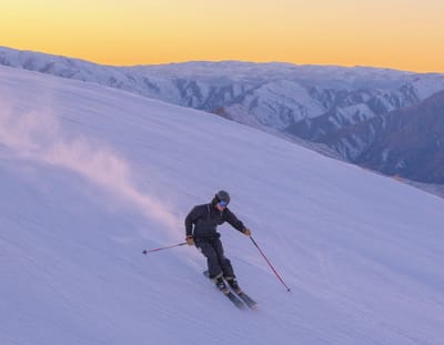
Global Weekly Snow Roundup #322
Weekly Global Snow News, updated 8 July 2026: New Zealand leads with 80cm (32”) snowfall, while Australia and the Andes improve as Northern Hemisphere summer skiing declines.

Next 3 days weather summary:Chuva intensa (total 30.0mm), mais intensa durante Quinta à noite. Muito ameno (máx. 19°C na Sexta à tarde, mín 11°C no Sábado à noite). o vento será geralmente fraco. | Dias 4-6 Jay Peak Resumo do TempoAlguns chuviscos, mais intensos durante Quarta de manhã. quente (máx. 25°C na Terça à tarde, mín 14°C no Domingo à noite). Ventos aumentam (calmo no Domingo à tarde, ventos fortes de Oeste na Terça à noite). | ||||||||||||||||
Qui 9 | Sexta 10 | Sábado 11 | Domingo 12 | Segunda 13 | Terça 14 | ||||||||||||
tarde | noite | manhã | tarde | noite | manhã | tarde | noite | manhã | tarde | noite | manhã | tarde | noite | manhã | tarde | noite | |
chuva mod. | chuva forte | aguaceiros | aguaceiros | aguaceiros | parcial/ nublado | parcial/ nublado | céu limpo | céu limpo | céu limpo | céu limpo | parcial/ nublado | céu limpo | parcial/ nublado | parcial/ nublado | parcial/ nublado | parcial/ nublado | |
km/h | |||||||||||||||||
Mapa de neve |  |  |  | 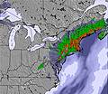 | 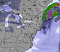 | 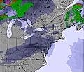 | |||||||||||
— | — | — | — | — | — | — | — | — | — | — | — | — | — | — | — | — | |
mm | 6 | 20 | 2 | 1 | 1 | — | — | — | — | — | — | — | — | — | — | — | — |
max °C | 18 | 17 | 16 | 19 | 16 | 16 | 17 | 14 | 16 | 19 | 17 | 19 | 22 | 20 | 23 | 25 | 23 |
min °C | 18 | 15 | 15 | 18 | 13 | 14 | 17 | 11 | 14 | 18 | 14 | 16 | 20 | 19 | 20 | 25 | 18 |
chill °C | 18 | 14 | 14 | 18 | 13 | 13 | 17 | 10 | 13 | 18 | 13 | 15 | 20 | 18 | 20 | 25 | 17 |
Humid. % | 88 | 96 | 80 | 54 | 79 | 52 | 51 | 73 | 51 | 48 | 72 | 54 | 53 | 60 | 53 | 50 | 84 |
Nível de congel. m | 4050 | 3850 | 3600 | 3500 | 3200 | 3300 | 3250 | 3500 | 3700 | 3750 | 3900 | 4000 | 4300 | 4700 | 4950 | 4850 | 4400 |
— | — | 5:11 | — | — | 5:13 | — | — | 5:13 | — | — | 5:15 | — | — | 5:16 | — | — | |
— | 8:37 | — | — | 8:36 | — | — | 8:36 | — | — | 8:35 | — | — | 8:34 | — | — | 8:34 | |
Vire pro e carve em:
Informações de avalanche: National Avalanche Center
Últimos relatórios de neve perto de Jay Peak:
| Profundidade da neve no topo | — |
|---|---|
| Profundidade da neve mais baixa | — |
| Profundidade da queda de neve fresca | — |
| Quando foi a última vez que nevou? | 29 May 2026 |
0.0 | Dias de sol com neve pó Neve fresca, principalmente ensolarado, vento fraco. |
|---|---|
0.0 | Dias de neve pó Neve fresca, sol limitado, qualquer vento. |
0.0 | dias de sol Neve média, na maioria das vezes ensolarado, vento fraco. |
As tabelas acima dão a previsão do tempo para Jay Peak à altitude específica de 881 m. Nossos sofisticados modelos de tempo permitem-nos obter a previsão de neve para estações no topo, na parte média e na baixa de Jay Peak. Para acessar a previsão do tempo para outras elevações, utilize o botão tab acima da tabela. Para uma visão mais ampla do tempo, dê uma olhada em Weather Map" of United States.
Click here para ler mais informações sobre os níveis de congelamento e de como nós prevemos nossas temperaturas.
Geral 3.8 baseado em 23 Votos e 9 avaliações
Just trying to purchase gift cards for Christmas was a nightmare. They process the money from your charge card and send nothing out.
Jack de United States escreve:
Just trying to purchase gift cards for Christmas was a nightmare. They process the money from your charge card and send nothing out.

 Nearest